Photo: Snow covers the Pacific Crest Trail north of Forester Pass
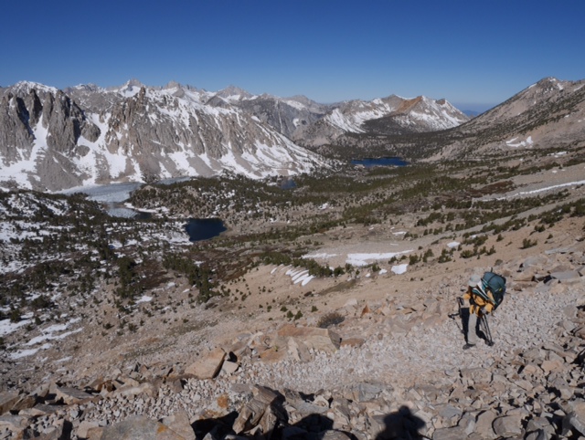
Day 61: Pacific Crest Trail to Independence, CA via Kearsarge Pass
Today we hiked 7.5 miles down a side trail over Kearsarge Pass to a place called Onion Valley. Then we got a ride 13 miles down the road to Independence, CA. It really is amazing how a short 7.5 mile (return) hike from a paved road can put you right in the middle of the Sierra (although you do have to climb 2,700 over Kearsarge Pass to get there).
We are staying in the Courthouse Motel, which is a small hiker-friendly establishment. Not much to this town actually — the motel, two gas stations, post office, and two restaurants. It is the county seat of Inyo County, so there is a big courthouse across the street.
We plan on taking a rest day here tomorrow and start the next leg of our hike to Vermillion Valley Resort on Wednesday.
Mileage: 6/10 mile on PCT, then 7.5 off trail
—–
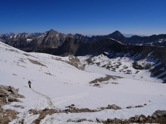
Day 60: Mile 778.2 to Bullfrog Lake trail junction
It was a chilly morning as we made breakfast and gathered up our cold weather gear (waterproof socks, tall gaiters, snow baskets for our trekking poles). We were camping as close as we could to the base of Forester Pass because the snow would be hard in the morning but become soft and slushy in the warmth of the afternoon.
There was quite a lot of snow at the base of Forester Pass but we were able to find the trail and the switchbacks. The climb did not require the use of our crampons and ice axes; we were able to keep traction with just our hiking shoes and poles.
But once on top of Forester, we could see that our downhill trail to the north was buried under snow for at least a mile. We followed snow prints made by other hikers down to the actual Pacific Crest Trail. We wanted to glissade part of the way but no path was clear of exposed boulders.
Part of the rest of the day we traveled on wet muddy trail, since all the snowmelt is following the same trail down until the trail dropped to about 10,000 feet in elevation. Then the trail followed the lovely Bubbs Creek through a wonderful forest and Vidette Meadow. We can see the snow covered mountains that we just walked through in the distance and they are very beautiful.
Mileage: 10.3
——
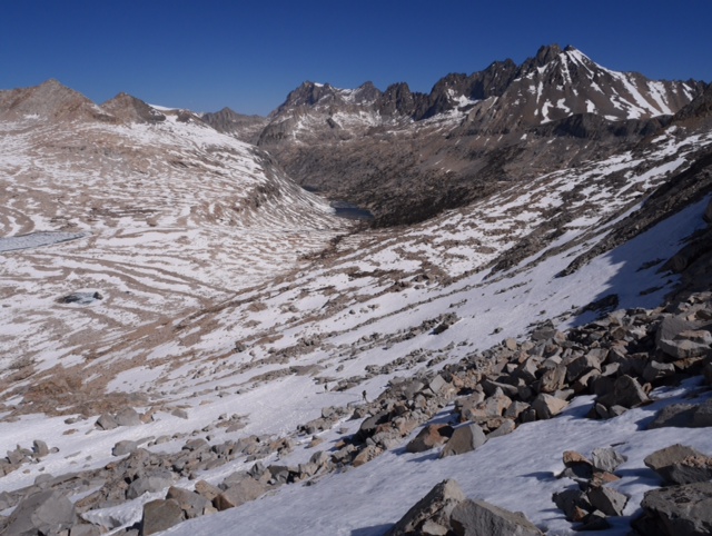
Day 59: Crabtree Meadow to Mile 778.2
We are camped tonight below Forester Pass at 12,200 feet. Tomorrow morning we will hike over the pass which is the highest point on the Pacific Crest Trail. We encountered our first real snow about 1.5 miles south of here, but it was easy to cross. Nearby lakes are still frozen.
Overall we had a relaxing day (! Deb says lots of climbing still !!) with a long stop this afternoon at Tyndall Creek, the third water crossing getting our feet wet today. Deb is finding it difficult to stop carrying more than one liter of water at a time despite the plentiful water here, a carryover from our dry hiking days of only a week ago.
Mileage: 11.2
—–
Day 58: Mile 747.2 to Crabtree Meadow
This morning was cold since we were cowboy-camped above 10,000 feet. This does not deter Lon from setting the alarm for 5:10 a.m. Brrrrr. Deb has to hike chasing the sun in the mornings nowadays.
Once we reached Chicken Spring Lake, we were in the Sierra we both admire and remember fondly: expansive views of surrounding mountains and meadows, granite cliffs, big steps made of boulders and tree stumps/branches, bigger and bigger climbs, rocky trails, and numerous streams to step over. It was fun to finally be above treeline at times. We climbed above 11,300 feet, we think more than once.
We are now cowboy-camped at Crabtree Meadow, tired after 19 miles today. No snow encountered on the Pacific Crest Trail yet but we see small patches infrequently. We are watching the deer in the meadow and guarding our food from the marmots.
Mileage: 19.1
—–
Day 57: Death Canyon to Mile 747.2
The Pacific Crest Trail keeps climbing and gaining elevation as we hike northward. Our day was full of ups, small downs, and even higher uphills – it challenges us both physically and mentally. The trail likes to cling to the mountainsides at this point, giving us only brief glimpses through the trees of the green valley below.
We are camped tonight at 10,800 feet. We are expecting a chilly night. Tomorrow morning we will cross 11,000 foot Cottonwood Pass.
Mileage: 16.4
—–
Day 56: Mile 719.2 to Death Canyon
We have been gaining elevation and it was chilly last night. We stayed warm in our sleeping bags, but Deb was slow to wake up.
The hike today reached almost 10,500 feet, the highest elevation so far for this hike. We are feeling the effects of the elevation and decided to make this a short day to adjust to the altitude. Death Canyon, where we are camping, is actually pretty nice despite the name.
We’ve been treated to spectacular scenery and we know this is just the beginning for the climbs to come. Interestingly, we have also been treated to low-flying military fighter jets whizzing by in these canyons – their supersonic sounds echo loudly overhead.
Mileage: 11.6
—–
Day 55: Kennedy Meadows to Mile 719.2
We left Kennedy Meadows powered by our new breakfast choice: hot and creamy polenta – yep, we are eating this wonder food for this entire week! This is also the first week that we stop sharing dinners. As a result, our packs are heavier with food. Still we managed to keep our mileage respectable today. The first part of the day had us walking the high desert; sadly, some of it another burn area. Next we climbed into beautiful pine forest and then dropped into a huge meadow and eventually down to the South Kern River where we soaked our tired feet and then made dinner. We hiked on for another 2.7 miles to cowboy camp in the pines at 8200 feet – brrrr, a little chilly tonight.
Mileage: 17 miles


You must be logged in to post a comment.