Categories
Walking

Day 68

photo4
At Muir Pass

Day 68: June 9th
Mile 835.8 to 850.9

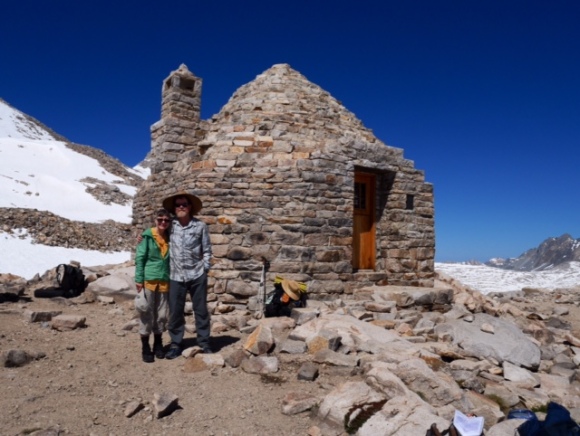
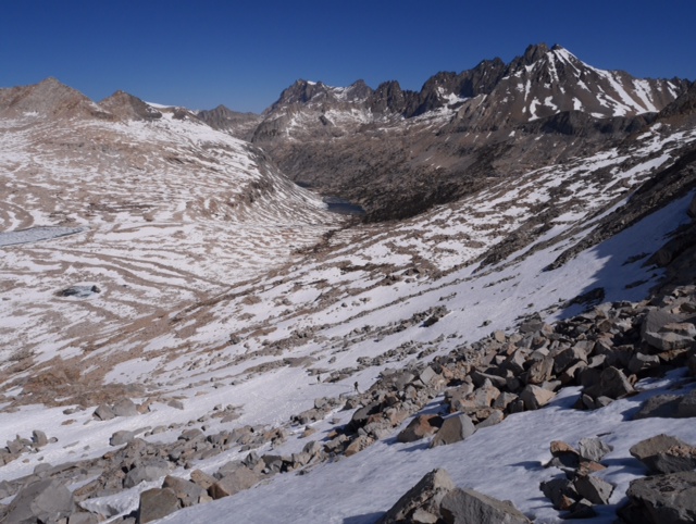
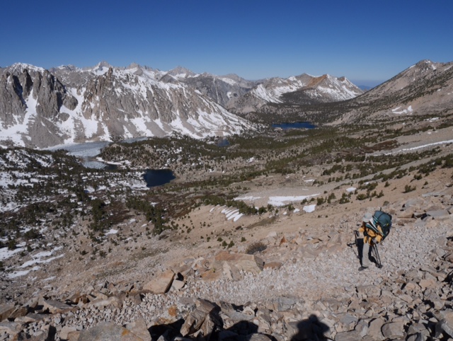
Despite our best plan to position ourselves for Muir Pass, the effort required to go up and down this pass surprised us. Fairly deep snow was everywhere (it seemed.) We got our shoes wet within 15 minutes and they stayed wet until we stopped for lunch, the first time all day that we were out of the snow. It took us about 7 hours, including a rest at the Muir stone hut at the summit, to go up and over and down to the first snow-free campsite to eat lunch. In comparison it took us 4 hours the rest of the day to go 8 miles down to our campsite for the night at Evolution Creek. A very tough day. The downhill over the pass was deep with snow for miles and we seemed to posthole every 3 steps. But we did feel like kids as we gave up the effort to avoid water streaming down the trail and simply splashed through the water and mud puddles without any more care.

On the bright side, we encountered the most PCT hikers this day and enjoyed talking with them at the Muir hut, down the trail, and now here at our campsite.

Mileage: 15.1 miles

Categories
Walking

Day 67

Day 67: June 8th
Mile 824.4 to 835.8

Today we took an on-trail nero, only hiking about 8 miles along a very pretty section of the Pacific Crest Trail. We took several long breaks, rinsed some clothes, relaxed. We are camped 2.8 miles south of Muir Pass (12,000 feet) which we will hike over early tomorrow morning. We expect a lot of snow from the reports of south-bound hikers we encountered today.

Mileage: 8.4 miles

Categories
Walking

Day 66

Day 66: June 7th
Mile 813.3 to Mile 827.4

Mather Pass (12,100 feet) looked easy when we viewed it from below. Not much snow was visible to our eyes. But the Sierra is deceptive and left snow laying in snow piles at the base which we discovered after rounding the top of some low hills. We followed the trail up ignoring the snow left by previous hikers seemingly going straight up. At the summit, we found the north side covered in some treacherous snow and quickly donned our crampons for the descent. We continue to underestimate our times to go up and over these passes: they are more difficult than they look. Deb is also not amused with all the water crossings getting our feet wet within 30 minutes of beginning our day.

Photo: Looking north from Mather Pass.

Mileage: 14.1 miles

Categories
Walking

Day 65

Day 65: June 6th

Mile 801.5 to 813.3

Today’s Sierra pass was 12,100 foot Pinchot Pass and last nights campsite set us up poorly for this pass today. We were camped 5.6 miles south of Pinchot but 3,000 feet below it, so it was a bit more of a climb than ideal. This combined with an unusual phenomenon that Pinchot had more snow south of the pass than to the north made it difficult hiking. Ideally we should have been closer and higher. But we made it over the pass and everything worked out OK.

This time of year snow in the Sierra freezes hard overnight and then softens as it’s warmed by the sun during the day. By mid-day the snow can get pretty soft and you will often sink knee deep or more into the soft snow making walking very difficult. If you start early on the hard snow you can make pretty good time.

This part of the Sierra has 12,000 foot passes every 12 or 15 miles. We try and position ourselves to be only a few miles below a pass in the morning. Our mileage is low because we don’t want to cross two passes a day since the second pass would be on soft afternoon snow (not to mention it’s a bit of work to climb 3,000 – 4,000 feet up each pass).

South and west faces of mountains usually have less snow because they receive more sunlight. Since we are hiking from south to north this usually means the south side of the passes that we ascend will have less snow than the north side that we descend.

Photo: Deb crosses a stream after Pinchot Pass.

Mileage 11.3

Categories
Walking

Day 64 – Glen Pass

Day 64: June 5th
Mile 788.9 to Mile 801.5

After climbing Kearsarge Pass the previous day to return to the Pacific Crest Trail, we camped low at Charlotte Lake to re-adjust to the elevation. In the morning we began the 2 mile climb to Glen Pass, which peaked for us at 11,950 feet. The climb up was through a beautiful canyon and snow covered the trail little until we neared the switchbacks at the top. We didn’t need our crampons until we climbed over the top and saw the steep downhill slope completely covered in snow. We were down and out of the snow in less than a mile, but still Deb postholed half a dozen times. The warmer temps today are melting the snow quickly.

In the afternoon we leisurely strolled down through Rae Lakes and Dollar Lake down, down, down to Woods Bridge. Once again we marveled at the picturesque scenery: snow-covered mountains, alpine lakes with golden trout, and roaring streams of water everywhere.

Tonight we are camped up another canyon with a river roaring besides us. We will climb Pinchot Pass in the morning.

Photo: Deb coming down the snowy north side of Glen Pass.

Mileage: 12.6

Categories
Walking

Day 62-63: June 3-4th Independence, CA back to PCT Mile 788.9 via Kearsarge Pass

We had a restful and relaxing zero day in Independence, CA. We shipped a box of supplies and added a few items from the gas station mini-mart. We also shipped back our ice axes, but kept our crampons for the high passes ahead.

In the small world department: we met the brother and nephews of our friend San Diego trail angel Girl Scout on the top of Kearsarge Pass.

Photo: Deb hiking over Kearsarge Pass on the way to Independence, CA