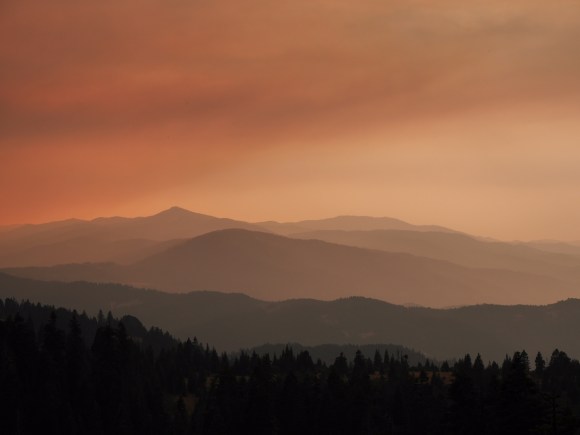
Lon got a late start hiking as is typical of most town days. Smoke from the area wildfires was not too bad this morning but increased as the day went on. None of the fires are near the section of the Pacific Crest Trail he is hiking today, although a fire is burning near the trail about 40 miles to the north.
Callahan’s is a nice, hiker-friendly lodge with excellent food that lets hikers camp on the back lawn. Unfortunately it’s close proximity to Interstate 5 made for a noisy night. We moved to the Ashland Motel Friday which was convienantly located and allowed easy access to the grocery store, outfitter, bank, and Post Office.
We took care of our town business including checking on airport transportation for Deb. She has decided to stop hiking at Ashland and will return to Oregon with Lon’s car to sightsee and support his hike. Lon will continue hiking on to Canada.
Today’s hike along the Pacific Crest Trail was mostly high on the ridgetops and we could see many of the wildfires started by the previous day’s thunderstorms. The Ashland paper reported 34 fires were started. Most were small and some distance away but still it was alarming to see two or three new fires with each ridge we crossed or bend the trail made. Toward the end of the day the smell of smoke was very noticeable. We stopped at Callahan’s Lodge for the night.
We strolled out of camp this morning at 6:30 am since we had done the two climbs yesterday (almost 7000 feet!) The trail meandered around the tops of the mountains all day: up, down, around. The typical PCT day.
Until, finally, really, no mirage, we hiked over the Oregon-California state lines at 4 pm. Egads, we had completed a thru-hike of the entire state of California!
We feel privileged to have made it this far in under 4 months – wow, that is a really long time to be on the trail. And still be walking! Because we were chased out of California by late afternoon thunderstorms: we saw two, and maybe three, forest fires started by the lightening. The smoke made Deb nervous so we hiked three miles further today to put more distance between us and the fire and to camp near a road.
So here is the recap of our dramatic day: fires, rain, state borders, and 1700 miles. We are safe and happy and overwhelmed in our tent tonight, watching the stormy skies.
We planned an early start this morning and got going on the half mile road walk to the trail at 5:30 am. A lot of the hikers camped with us at the RV park started at least an hour earlier.
This climb is a big topic among hikers, who dread the 5,000 foot elevation gain over 13 miles, the exposure, and the heat. As we found out today, it is not any steeper than the climb out of Belden and is nicely graded to get you up quickly. The early start meant a somewhat cool morning which also helped since there isn’t much shade. And the exposure just gives you beautiful views – this last section of California (yes!!! we are almost at the state border) is not to be missed.
We completed 15 miles by 2 pm and took a siesta under some shady trees, fixed an early dinner at 4:30 pm, and hiked another 3 miles to our campsite high in the mountains.
We forgot to mention meeting our first true southbounders yesterday, Mike and Cam, who started June 16. They had encountered 48 northbounders in one day! No wonder we have a hard time finding unoccupied campsites anymore.
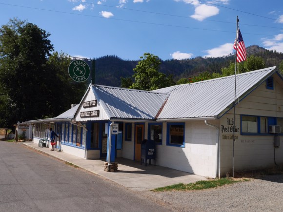
The Seiad Valley, CA store, cafe and post office share this building.
Day 117: July 28th
Mile 1647.8 to Mile 1662 (Seiad Valley)
Today was a short 14 mile hike to the small community of Seiad Valley where we have a resupply box waiting. It’s hot here — about 100 degrees. We are resting in the shade at an RV park with about 20 other hikers waiting out the heat of the day. We will hike out at 5 am tomorrow. It’s a steep long climb but it will be cooler once we reach the top.


You must be logged in to post a comment.